
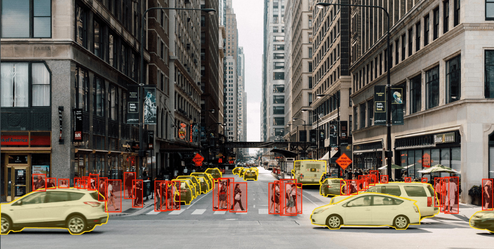
Introduction Real-time LiDAR annotation is at the cutting edge of technology, driving rapid advancements in various industries. LiDAR (Light Detection and Ranging) technology provides critical spatial data that can be transformed into actionable insights through the process of annotation. As industries increasingly demand real-time decision-making, LiDAR annotation has emerged as a core component in applications like autonomous driving, smart cities, and real-time environmental monitoring. This blog explores the significance of real-time LiDAR annotation for live applications, the industries it impacts, the challenges faced, current tools and technologies, and future trends that will shape its evolution. Understanding Real-Time LiDAR Annotation 1.1 What is LiDAR? LiDAR (Light Detection and Ranging) is a technology that measures distances using laser light to generate precise, 3D representations of an environment. LiDAR sensors can capture millions of data points in the form of point clouds, representing objects, structures, and terrain. When processed, these point clouds offer a high level of detail for mapping and analysis. LiDAR technology has been widely adopted for applications in various industries, ranging from urban planning and infrastructure monitoring to autonomous vehicles and robotics. However, raw LiDAR data alone is not sufficient for these applications—it needs to be processed and annotated for systems to make sense of it. 1.2 The Role of Annotation Annotation refers to the labeling or classification of objects within LiDAR data. In real-time applications, this process involves instant categorization of the data as it is captured by the sensor. For example, in an autonomous vehicle, the system must be able to recognize pedestrians, vehicles, and obstacles in real time to navigate safely. Real-time annotation enables systems to extract meaning from raw data, allowing machine learning models and AI systems to make informed decisions. Without annotation, LiDAR data is simply a collection of points with no contextual information. 1.3 Why Real-Time Annotation Matters In industries where time is critical, such as autonomous driving or dynamic traffic management, the ability to process and annotate data in real time is essential. Real-time annotation means that systems can make immediate decisions based on incoming data without delays. For example, in an autonomous vehicle, detecting a pedestrian crossing the road in real-time allows the system to react instantly to prevent accidents. Real-time annotation is also crucial in other fields, such as urban planning, where continuous monitoring of infrastructure projects and construction sites can be enhanced through instant insights from annotated LiDAR data. Key Applications of Real-Time LiDAR Annotation Real-time LiDAR annotation has a wide range of applications in various industries. Here are some key sectors where real-time LiDAR annotation is transforming the way data is used. 2.1 Autonomous Vehicles The most well-known application of real-time LiDAR annotation is in the development of autonomous vehicles. Self-driving cars rely on LiDAR to create 3D maps of their environment and make real-time decisions to navigate safely. Annotating objects like pedestrians, vehicles, road signs, and obstacles in real-time allows autonomous vehicles to react instantly to changing conditions on the road. In this context, real-time LiDAR annotation is used for: Object Detection: Detecting and classifying objects like vehicles, pedestrians, cyclists, and obstacles. Path Planning: Mapping out a safe and efficient route based on annotated environmental data. Collision Avoidance: Predicting the movements of nearby objects and adjusting the vehicle’s trajectory to avoid collisions. 2.2 Smart Traffic Management Smart cities are adopting real-time LiDAR systems to optimize traffic flow and manage urban transportation networks. Real-time annotation helps identify and classify vehicles, pedestrians, and other road users, enabling dynamic traffic management systems to adjust traffic signals, reroute vehicles, and prevent congestion. Key benefits of real-time annotation in traffic management include: Vehicle and Pedestrian Detection: Monitoring traffic patterns and pedestrian crossings for safety. Dynamic Traffic Control: Optimizing traffic signal timings and rerouting vehicles in real time to reduce congestion. Incident Detection: Identifying accidents or unusual traffic patterns to dispatch emergency services promptly. 2.3 Robotics and Drones LiDAR-equipped robots and drones are increasingly used in industries like logistics, construction, and agriculture. These machines rely on real-time LiDAR annotation to navigate complex environments, detect obstacles, and perform tasks autonomously. For example, drones equipped with LiDAR sensors can be used to monitor construction sites, inspect infrastructure, and map large areas in real time. Annotated LiDAR data enables these drones to identify objects and structures accurately, allowing them to make informed decisions during flight. 2.4 Urban Planning and Infrastructure Monitoring Real-time LiDAR annotation is revolutionizing the way cities are planned and managed. City planners and engineers use LiDAR data to monitor infrastructure projects, update maps, and inspect structures in real time. Annotated data helps them identify potential issues and make informed decisions about the future of urban development. For example, real-time LiDAR annotation can be used to: Monitor Construction Sites: Track progress on infrastructure projects and detect potential safety hazards. 3D Mapping: Create detailed, up-to-date maps of urban environments for planning and development. Infrastructure Inspection: Identify defects or weaknesses in buildings, bridges, and other structures to enable timely repairs. 2.5 Environmental Monitoring LiDAR technology is also used for environmental monitoring, helping researchers track changes in landscapes, forests, and coastlines. Real-time LiDAR annotation allows for immediate analysis of environmental data, enabling quick responses to natural disasters, deforestation, or erosion. For example, drones equipped with LiDAR sensors can monitor forests for illegal logging or assess the impact of natural disasters on ecosystems. Annotated LiDAR data provides researchers with the information they need to take action in real time. Challenges in Real-Time LiDAR Annotation While real-time LiDAR annotation offers significant benefits, it also presents several challenges that must be addressed to achieve accurate and efficient results. 3.1 High Data Volume LiDAR sensors generate massive amounts of point cloud data, which can be difficult to process in real time. A single LiDAR scan can capture millions of data points, and the need for continuous, high-speed processing adds to the complexity. Processing this data in real time requires high-performance computing resources and optimized algorithms to ensure that systems can keep up with the flow of incoming data. 3.2 Computational Complexity

Introduction The concept of a smart city revolves around the integration of digital technology and data-driven strategies to enhance urban life, optimize resources, and improve public services. LiDAR (Light Detection and Ranging) technology, an advanced remote sensing system that generates highly accurate 3D data, has emerged as a crucial tool in this transformation. By capturing detailed spatial information about cities, LiDAR supports key urban functions such as infrastructure monitoring, urban planning, and traffic management. However, the raw LiDAR data generated through these systems needs precise annotation to be useful for machine learning models and decision-making algorithms. LiDAR data annotation involves labeling and categorizing various objects and environmental features within point cloud datasets, which helps machines interpret the 3D data correctly. In the context of smart cities, the accurate annotation of LiDAR data plays a critical role in enabling autonomous systems to monitor infrastructure conditions, plan urban developments, and manage traffic efficiently. This blog explores the profound impact of LiDAR data annotation on smart cities, focusing on its applications, challenges, tools, and future trends. Understanding LiDAR Technology and Smart Cities LiDAR technology is based on the emission of laser pulses that reflect off surrounding objects, allowing the sensor to measure distances and create 3D representations of the environment. When applied in smart cities, LiDAR becomes an essential tool for acquiring detailed, real-time spatial data, which can be used in various public and private sector applications. 1 What Makes a City “Smart”? A smart city is characterized by the deployment of connected sensors, data analytics platforms, and communication networks that work together to optimize urban operations. These components help monitor and manage critical city functions such as traffic flow, energy distribution, environmental monitoring, and infrastructure maintenance. By enabling data-driven decision-making, smart cities aim to reduce energy consumption, enhance public safety, and improve the overall quality of life for residents. 2 The Role of LiDAR in Smart Cities LiDAR is a critical element in many smart city initiatives. Its high-resolution 3D data provides detailed insights into the urban landscape, which is essential for monitoring the condition of roads, bridges, and buildings, planning future urban development, and managing traffic flow. LiDAR’s ability to operate in low-light conditions and capture vast areas quickly makes it indispensable for cities undergoing rapid change and expansion. The Importance of LiDAR Data Annotation Raw LiDAR point cloud data, while rich in information, is difficult for machines to interpret without proper labeling. LiDAR data annotation is a process that involves manually or automatically labeling objects, structures, and features in the point cloud to make the data usable for machine learning algorithms and decision-making systems. 1 Why Annotation Matters in Smart Cities In smart cities, accurate data annotation enables city planners, engineers, and AI-driven systems to interpret 3D data for infrastructure monitoring, urban planning, and traffic management. Proper annotation ensures that the machine learning models can distinguish between different types of objects, such as vehicles, pedestrians, roads, and buildings, and understand their relationships to make informed decisions. For example, in traffic management systems, annotated LiDAR data helps autonomous vehicles and smart traffic lights detect and predict the movement of cars, bicycles, and pedestrians, reducing the likelihood of accidents and improving the flow of traffic. 2 Benefits of Accurate LiDAR Data Annotation Improved Decision-Making: By ensuring that all objects are correctly labeled, annotated LiDAR data improves the accuracy of models used for urban planning and traffic management. Efficiency Gains: Automated systems can process annotated data faster than raw data, speeding up the analysis and decision-making process. Safety Enhancements: In infrastructure monitoring, precise annotation helps detect cracks, structural weaknesses, and other potential hazards, allowing for timely maintenance and repairs. LiDAR Data Annotation for Infrastructure Monitoring Smart city infrastructure, including roads, bridges, tunnels, and buildings, requires constant monitoring to ensure safety and longevity. LiDAR technology, combined with accurate data annotation, enables detailed inspection and analysis of these structures. 1 Infrastructure Monitoring with LiDAR LiDAR systems mounted on drones or vehicles can scan large areas of a city’s infrastructure, creating high-resolution 3D models that capture even minute changes over time. These models provide city authorities with the ability to monitor infrastructure health in real-time, identifying potential issues before they become critical. 2 Annotating LiDAR Data for Infrastructure For infrastructure monitoring, annotations focus on identifying key structural elements such as: Bridges: Annotating the individual components of a bridge (e.g., deck, supports, cables) allows for the detection of damage or wear. Roads: Annotating cracks, potholes, and other surface deformations helps optimize road maintenance schedules and reduce vehicle damage. Buildings: Building façade annotations allow for the assessment of material degradation, which is important for long-term maintenance and retrofitting. 3 Real-World Applications: Infrastructure Monitoring Systems Several cities around the world have implemented LiDAR-based infrastructure monitoring systems: New York City: LiDAR data is used to monitor the structural health of its bridges and tunnels, providing real-time alerts for repairs. Singapore: The government uses annotated LiDAR data to assess building safety and manage urban development projects. LiDAR Data Annotation in Urban Planning As cities grow, the need for intelligent urban planning becomes more critical. LiDAR data helps planners visualize the current state of the urban environment and project future developments. However, this data must be accurately annotated to create actionable insights for urban development projects. 1 LiDAR in Urban Planning LiDAR is used in urban planning for tasks such as: Topographical Mapping: Creating accurate 3D maps of the landscape to inform land use decisions. Building Height and Density Analysis: Assessing the current height and density of buildings to guide zoning regulations. Green Space Analysis: Mapping green areas and annotating vegetation to plan for parks, gardens, and recreational areas. 2 Annotating LiDAR Data for Urban Planning The annotation process for urban planning focuses on classifying different types of land use, buildings, roads, and natural features. This enables planners to: Model Urban Growth: Predict how a city will expand over time based on current data and annotated trends. Optimize Land Use: Maximize the efficiency of available land while considering factors such as
Introduction In an era where technology is advancing at breakneck speeds, LiDAR (Light Detection and Ranging) has emerged as a pivotal technology that is reshaping industries such as autonomous driving, robotics, smart cities, and geospatial intelligence. At its core, LiDAR is a remote sensing technology that utilizes laser beams to measure distances between the sensor and surrounding objects, producing precise 3D representations of environments. However, for these systems to understand and utilize the vast amounts of LiDAR-generated data, accurate data annotation is essential. LiDAR data annotation is the process of labeling and categorizing point clouds, which is critical for developing and refining machine learning models used in various applications. This comprehensive guide delves into the world of LiDAR data annotation, exploring its significance, methodologies, challenges, tools, and its role in the future of technology. Understanding LiDAR Technology LiDAR, initially developed for military and geological applications, has found widespread use in modern technological systems. It operates by emitting laser pulses and measuring the time it takes for these pulses to return after hitting an object. This time delay helps determine the distance between the LiDAR sensor and the object, creating a detailed point cloud representing the environment in 3D. 1 How LiDAR Works LiDAR consists of three primary components: Laser emitter: Sends out thousands to millions of light pulses per second. Sensor or detector: Captures the reflected light, measuring the time taken for the laser to return. GPS and IMU: These provide geolocation and orientation data to accurately place the LiDAR data in context. When combined, these elements allow LiDAR systems to generate highly accurate 3D models of their surroundings. Depending on the application, LiDAR can be mounted on vehicles, drones, aircraft, or satellites. 2 LiDAR vs. Other Sensing Technologies LiDAR is often compared to other sensing technologies such as radar and cameras. While radar uses radio waves to measure distances and cameras provide visual data, LiDAR excels in accuracy, especially for measuring fine distances and detecting objects at long ranges, even in poor lighting conditions. Importance of LiDAR Data Annotation While LiDAR sensors capture vast amounts of data in the form of point clouds, these raw datasets are essentially meaningless without proper annotation. Annotating LiDAR data allows machines to understand and interpret the 3D world, helping in applications such as object detection, scene segmentation, and tracking. 1 The Role of LiDAR Data Annotation in Autonomous Driving Autonomous vehicles rely heavily on LiDAR data to navigate through complex environments. LiDAR helps these vehicles detect pedestrians, other vehicles, road signs, and obstacles. For instance, Tesla, Waymo, and other major players in the autonomous vehicle industry invest millions into LiDAR data annotation to improve their AI models. Without accurate annotations, vehicles would be unable to recognize and differentiate between various elements in their environment, leading to catastrophic consequences. 2 LiDAR Data Annotation in Smart Cities LiDAR plays a key role in the development of smart cities by providing detailed 3D maps of urban environments. Accurate annotation of LiDAR data aids in infrastructure monitoring, traffic management, and the optimization of public services. For instance, annotated LiDAR data can be used to monitor building integrity, assess traffic flow, and even manage energy consumption in real-time. 3 Robotics and LiDAR Data Annotation Robotics systems, especially those operating in dynamic environments like warehouses, rely on LiDAR for navigation and obstacle avoidance. Properly annotated LiDAR data enables robots to create accurate maps of their surroundings, detect objects, and make decisions in real-time. The Process of LiDAR Data Annotation LiDAR data annotation is a meticulous process that requires both human expertise and advanced software tools. The main objective is to label different elements in the point cloud, such as vehicles, pedestrians, buildings, and other objects of interest. The process typically involves the following steps: 1 Data Preprocessing Before annotation begins, LiDAR data often needs to be cleaned and preprocessed. Raw LiDAR data can contain noise, outliers, and irrelevant information that could impede the annotation process. Preprocessing steps include: Noise removal: Filtering out erroneous points caused by atmospheric interference or sensor errors. Downsampling: Reducing the point cloud density to optimize computational efficiency without losing important details. Segmentation: Dividing the point cloud into smaller, manageable segments that can be more easily annotated. 2 Manual Annotation In manual annotation, human annotators label each point in the cloud according to its corresponding object or feature. This can involve: Object labeling: Identifying and categorizing objects like cars, pedestrians, trees, and buildings. Bounding boxes: Drawing 3D bounding boxes around objects to delineate their position and volume. Semantic segmentation: Assigning a class label to every point in the cloud to describe its category (e.g., road, building, vegetation). Manual annotation is labor-intensive but essential for generating high-quality datasets. In industries like autonomous driving, where safety is paramount, the accuracy of annotations can directly impact the performance of AI models. 3 Automated and Semi-Automated Annotation As the demand for large-scale annotated LiDAR datasets grows, automated and semi-automated annotation tools have been developed. These tools leverage machine learning algorithms to expedite the annotation process. They can detect objects and label points automatically, but still require human oversight to ensure accuracy. Automated tools: These tools can identify certain objects like vehicles and pedestrians based on pre-trained models. While they reduce the workload for human annotators, they can sometimes struggle with edge cases or novel environments. Semi-automated tools: In this approach, algorithms assist annotators by suggesting labels and bounding boxes, which can be manually adjusted as needed. This strikes a balance between speed and accuracy. 4 Quality Assurance Quality assurance (QA) is a critical phase in LiDAR data annotation. After the initial annotation, the data undergoes review to ensure that all objects are labeled correctly and that the annotations meet predefined quality standards. QA often involves multiple rounds of reviews, with feedback loops to correct errors and inconsistencies. Types of LiDAR Data Annotations There are several types of LiDAR data annotations, each serving different purposes depending on the application. Understanding these types is crucial for selecting the right annotation strategy
Introduction In the rapidly advancing field of autonomous vehicles, geospatial analysis, and environmental monitoring, LiDAR (Light Detection and Ranging) technology plays a crucial role. LiDAR generates high-resolution maps by illuminating a target with laser light and analyzing the reflected light. For AI and machine learning models to interpret LiDAR data accurately, it needs to be annotated precisely. This article explores the top LiDAR annotation service providers, highlighting their strengths, unique offerings, and the role of SO Development in this domain. Understanding LiDAR and the Importance of Annotation LiDAR uses laser pulses to create high-resolution 3D maps of environments. The technology involves emitting laser beams, measuring the time it takes for them to bounce back from surfaces, and using this data to generate detailed spatial information. This makes LiDAR crucial for applications requiring precise distance and depth measurements. However, raw LiDAR data is often cluttered with noise and requires annotation to identify and classify objects, delineate boundaries, and provide contextual information. Effective annotation is essential for applications such as: Autonomous Vehicles: For navigation, obstacle detection, and environment mapping. Environmental Monitoring: For assessing vegetation, topography, and land use. Urban Planning: For infrastructure development and management. Robotics: For enhanced perception and interaction with surroundings. Leading LiDAR Annotation Service Providers SO Development: SO-Development is a distinguished player in the LiDAR annotation services market. Known for their meticulous approach and innovative solutions, SO Development has carved a niche for themselves in various high-demand sectors. Key Features: Precision and Accuracy: Emphasis on delivering highly accurate annotations through a combination of skilled annotators and advanced tools. Innovation: Continuous development of new methodologies and technologies to enhance the annotation process. Client-Centric Approach: Custom solutions tailored to the specific needs and goals of each client. Industries Served: Autonomous driving, environmental monitoring, urban planning, and more. Unique Offerings: Specialized Expertise: Deep knowledge of industry-specific requirements and challenges, particularly in autonomous driving and urban planning. Flexible Solutions: Ability to adapt workflows and tools to meet the evolving needs of projects. Commitment to Quality: Rigorous quality assurance processes, including multiple review stages and validation mechanisms. Notable Projects and Clients: SO Development has worked with several high-profile clients and contributed to critical projects in the autonomous driving and environmental sectors, further establishing their reputation as a reliable and innovative annotation service provider. SuperAnnotate SuperAnnotate offers an end-to-end annotation platform designed to handle large-scale projects efficiently. Their LiDAR annotation services are optimized for high accuracy and speed. Key Features: AI-Powered Tools: Integration of AI to assist annotators and improve productivity. Customizable Workflows: Tailored annotation processes to fit specific project needs. Comprehensive Support: Dedicated support teams to assist clients throughout the project lifecycle. Industries Served: Autonomous driving, geospatial analysis, and robotics. Notable Clients: Amazon, P&G, and Tractable. Motional Motional, a company known for its autonomous driving technology, also offers LiDAR annotation services. They leverage their expertise in autonomous systems to provide high-quality annotated datasets. Key Features: Domain Expertise: Deep understanding of autonomous driving requirements and challenges. Robust Annotation Tools: Custom-built tools to handle complex LiDAR data annotation tasks. Quality Focus: Emphasis on high accuracy and consistency in annotations. Industries Served: Automotive, robotics, and transportation. Notable Clients: Hyundai, Aptiv, and Lyft. Scale AI Scale AI is a leading provider of data annotation services, including LiDAR annotation. The company leverages a combination of human annotators and advanced machine learning algorithms to deliver high-quality labeled datasets. Key Features: Automated Labeling Tools: Scale AI uses proprietary tools to accelerate the annotation process while ensuring accuracy. Quality Assurance: Multiple levels of quality checks and a consensus mechanism to maintain high standards. Customizable Workflows: Tailored solutions to meet specific project requirements, including object detection, segmentation, and classification. Industries Served: Autonomous driving, robotics, e-commerce, and geospatial analysis. Notable Clients: Toyota, Zoox, and Nuro. Alegion Alegion specializes in providing high-quality data labeling and annotation services for machine learning models. Their LiDAR annotation services are designed to support complex projects requiring detailed and accurate labeling. Key Features: Expert Annotators: Highly trained workforce with expertise in various annotation techniques. AI Integration: Use of AI tools to assist human annotators and improve efficiency. Customized Solutions: Tailored annotation workflows to meet the specific needs of different industries. Industries Served: Autonomous vehicles, agriculture, and defense. Notable Clients: IBM, Dell, and the United States Department of Defense. CloudFactory CloudFactory is a prominent provider of data labeling services, including LiDAR annotation. They combine human intelligence with cloud-based technology to deliver scalable annotation solutions. Key Features: Skilled Workforce: Highly trained annotators capable of handling complex projects. Scalability: Ability to scale operations quickly to meet project demands. Quality Control: Multi-step quality assurance processes to ensure high accuracy. Industries Served: Autonomous vehicles, healthcare, and agriculture. Notable Clients: Microsoft, Drive.ai, and Luminar. Conclusion The LiDAR annotation landscape is dynamic, with several key players offering specialized services to meet the diverse needs of various industries. Providers like Scale AI, Alegion, Motional, CloudFactory, and SuperAnnotate have distinguished themselves through their unique features, quality assurance processes, and ability to scale. SO Development stands out for its precision, innovation, and client-centric approach, making it a noteworthy contender in the LiDAR annotation market. Their contributions to critical projects in autonomous driving and environmental monitoring underscore their expertise and reliability. As LiDAR technology continues to evolve and its applications expand, the importance of high-quality annotation services will only grow. Choosing the right annotation partner will be crucial for companies looking to leverage LiDAR data effectively, and the providers highlighted in this article offer a strong starting point for making an informed decision. Visit Our LiDAR Annotation Service Visit Now